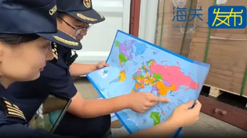
Chinese customs officers in eastern Shandong province have intercepted 60,000 maps that mislabelled the self-governed island of Taiwan, which Beijing asserts as its territory. The maps were intended for export and authorities noted they also omitted important islands in the contentious South China Sea, where territorial claims overlap with those of neighbors like the Philippines and Vietnam.
Describing the maps as problematic, customs authorities stated that their distribution compromises China’s national unity, sovereignty, and territorial integrity. The situation underscores the sensitivity surrounding cartography in relation to the geopolitical landscape, particularly regarding disputed maritime boundaries.
Notably, the maps failed to include the 'nine-dash line' — a demarcation crucial to Beijing's expansive claims in the South China Sea — while also neglecting to indicate the maritime boundary between China and Japan. Although it was not specified what the mislabelling of Taiwan entailed, the seizure compounds the broader tensions China faces regarding Taiwan, which maintains its distinct governance and identity.
Tensions frequently arise in the South China Sea, with another recent incident involving disputes between Chinese and Philippine vessels. The Philippines accused a Chinese ship of aggressive maneuvers, to which China responded by asserting the Philippine vessel posed a navigational threat.
Other countries in the region, such as Vietnam, similarly react strongly to perceived misrepresentations of territorial claims, with previous cultural outputs being censored for aligning with Beijing's territorial map interpretation.
This incident adds to a history of customs seizing maps that fail to meet standards; recent seizures include nautical charts with misrepresented national boundaries in previous months.