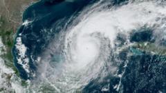
The National Oceanic and Atmospheric Administration (NOAA) had previously stated that data from three satellites, operated in conjunction with the DoD, would be taken offline by June 30 without a specific reason provided. However, following input from a NASA scientist regarding the vital nature of this data, the decision was reversed. NOAA cited significant cybersecurity threats as the rationale behind the initial decision to suspend the data.
This extension has been met with relief, although experts like Michael Lowry, a hurricane specialist, emphasized that it does not cover the critical peak hurricane months of August, September, and October when severe storms typically occur. The cancellation of data would have severely hindered forecast accuracy, thereby increasing risks to lives and property.
Additionally, this satellite data is key for climate research beyond hurricane forecasts, specifically studies related to changes in sea ice in the Arctic and Antarctic regions. Researcher Sharon Stammerjohn pointed out that satellite imagery is crucial for monitoring seasonal sea ice, which plays a vital role in reflecting solar energy and moderating global temperatures. Losing this data, particularly in remote areas like Antarctica, would hinder critical observations necessary for understanding climate change.
While alternatives from other international space agencies exist, they may not fully replace the specific nuances and calibrations provided by NOAA and DoD, adding further complexity to climate research efforts.