In brief
Massive floods in Nepal’s border region have prompted experts to warn India about the serious danger of transboundary rivers becoming catastrophic when stormwater, sediment and debris mix. The Kosi, Gandak, Bagmati and Ghaghara rivers, originating in Nepal, flow south into India’s flood‑prone plains, especially Bihar and eastern Uttar Pradesh. The peak flow at the border largely depends on Nepalian rainfall, but once in India, the severity depends on local river infrastructure, embankments and terrain. While India has some warning time of about 12 hours to two days, gaps remain in real‑time monitoring and joint forecasting. The lesson is that India’s preparedness must address shared hydrological risks and climate‑driven mountain hazards.
Why India Should Care About Nepal’s Floods
The 2026 floods that drenched Nepal’s eastern border have sent shock waves through the Indian plains. The rivers that rise above the Himalayas, such as the Kosi, Gandak and Ghaghara, carry far more water into India than their tributaries suggest—up to forty percent of the Ganges’ annual flow during dry seasons comes from Nepal. That makes India’s flood risk in Bihar and eastern Uttar Pradesh a real hazard: the “sorrow” of the Kosi could re‑emerge under new conditions.
The Hill‑to‑Plain Transition
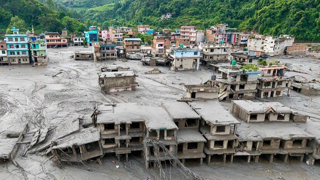
When heavy monsoon rain falls on steep, small catchments in Nepal’s Siwalik and Chure ranges, rivers sprint downstream in braided channels that lose much of their power in bold valleys but drop massive amounts of sediment. The shock of a sudden water surge mixed with mud and rock can reach the plains on the Pan‑Sattan river system in hours. That rapid, high‑energy flow, rather than a slow‑moving flood, is what turns a seemingly benign watershed into a life‑threatening disaster in India.
When the Water Meets India
Once the river flows south, the flood’s severity is shaped by India’s own infrastructure and land use. A dangerously low‑design embankment, a blockage by road or rail, or a clogged drainage network each amplify the risk. The 2008 Kosi breach is a classic example: the flood did not carry extraordinary water volumes, but the lack of maintenance on the embankment turned a manageable level into a 100‑kilometre‑long catastrophic slide. Hence, what matters is not only the water coming from Nepal, but the condition of India’s flood controls.
How Much Warning Is Possible?
With real‑time rainfall and river‑level feeds exchanged between the two nations, India enjoys roughly twelve hours to two days of early warning for monsoon floods, depending on the river. Flash floods from the Chure catchments can arrive within a few hours, while a landslide‑dam breach could push surge across the border in less than a day. Yet the nearly seven‑hour delay from the Rasuwa debris flow to its arrival in Triveni underlines a gap between watchful data and actionable warning at the village level.
The Misconception of “Water Release”
Many people think Nepal is the source of sudden releases into Indian rivers. In reality, Nepal holds very little storage; its main dam—Kulekhani—carries less than 0.1 cubic kilometres of water. India‑owned barrages on the Kosi and Gandak hold the water once it crosses the border, but the surge accompanying the current floods is driven largely by Nepal’s rainfall, not an intentional discharge.
The Bigger Challenge: Mountain Hazards and Climate Change
The Nepal floods are just one example of mountain‑zone hazards intensifying: debris‑laden floods that merge meltwater, rainfall and sediment become far more deadly than ordinary floods. After heavy monsoon storms, glacial lake outbursts, permafrost thaw and rock‑ice avalanches are increasingly expected, producing waves that travel over a thousand kilometres quickly. With a warming atmosphere increasing rainfall intensity, India’s risk is set to rise.
Key Take‑away for India
India’s focus should not be on blaming Nepal, but on collaborative data sharing, shared forecasting, and maintaining embankments and river infrastructure throughout the basin. Being ready for the kind of hybrid flood—a mix of water, sediment and rock—will make the difference between early warnings that save lives and delayed response that cost them.